
The UK's Connected Car Map Is Lying to You About Where the Cars Actually Are
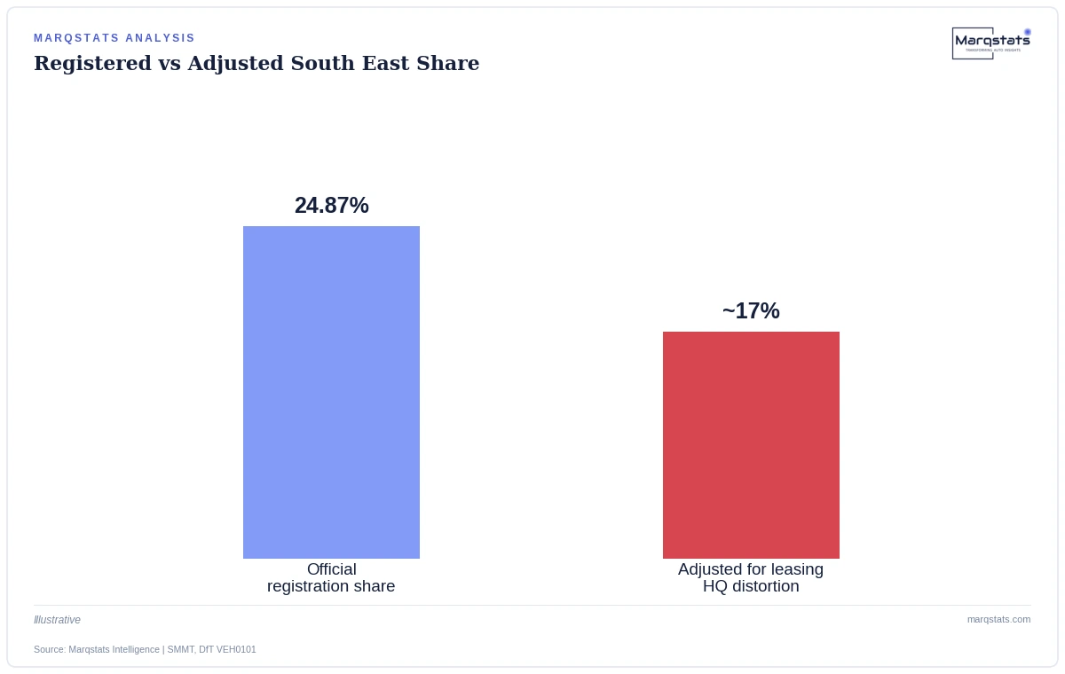
In brief: official SMMT Motorparc data shows nearly a quarter of all UK vehicles registered in London and the South East. That figure is real, and it is also substantially misleading if you are trying to understand where connected vehicles actually drive, charge, and generate telematics data day to day.
Why Registration Address Isn't Driving Location
Corporate fleet and long-term contract-hire vehicles are registered to wherever the leasing or finance company keeps its headquarters — heavily concentrated in Berkshire, Buckinghamshire and Greater London — regardless of where the actual driver lives, works, or spends most of their time on the road. A delivery van leased through a South East finance company and driven daily around Leeds shows up in national statistics as a South East vehicle, not a Yorkshire one.
This isn't a data-quality failure so much as a mismatch between what the registration system was built to track and what a connected-car market analysis actually needs from it. DVLA registration exists to establish legal ownership and taxation liability, not to map where vehicles physically operate — it was never designed to answer the question this analysis is asking of it, which is precisely why the mismatch exists at this scale.
The Scale of the Distortion
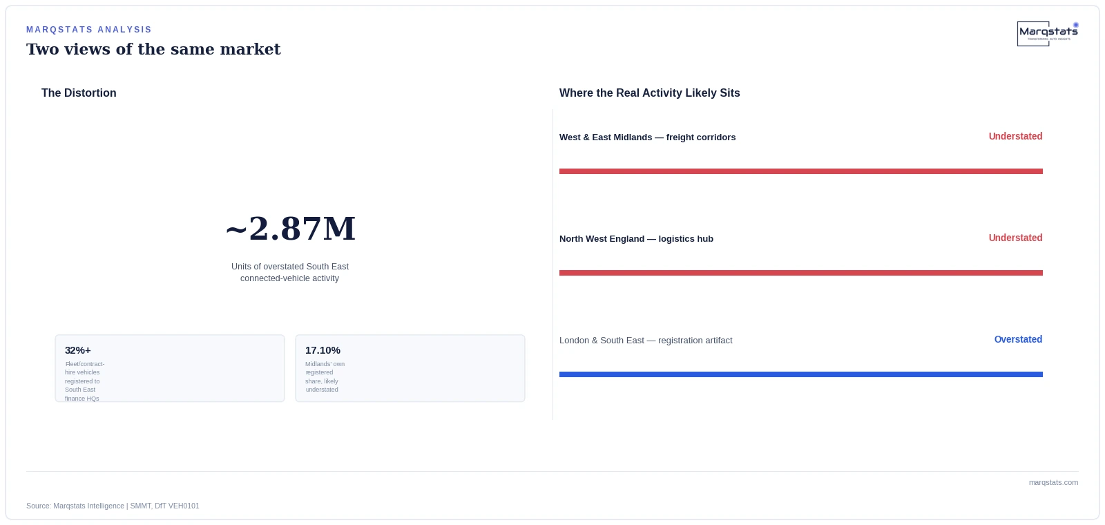
Cross-referencing DfT licensing data under Table VEH0101 against national leasing records reveals that more than 32% of all corporate fleet and long-term contract-hire vehicles are registered to finance headquarters in the South East despite being driven across the Midlands, the North West and Yorkshire specifically. The resulting distortion runs to roughly 2.87 million units — overstating South East connected-vehicle activity by that amount while understating it by a comparable margin across northern England.
To put 2.87 million units in perspective, that single distortion is larger than the entire registered vehicle parc of Scotland, Wales or Northern Ireland individually. A reconciliation error of this scale isn't a rounding issue at the margins of the data — it is large enough to meaningfully change which region actually deserves to be called the UK's largest connected-vehicle market once genuine driving activity, not registration paperwork, is the measure used.
It's also worth noting the distortion runs in one direction consistently, not randomly across regions: it always inflates wherever corporate finance and leasing headquarters cluster, and it always deflates wherever the actual freight, logistics and commuting activity happens instead. That directional consistency is precisely what makes the correction tractable in principle, even though nobody has yet built the reconciliation at national scale.
The UK's most connected region, on paper, is a finance-department artifact — not where the cars actually are.
— Marqstats Analyst Team
Why This Matters for Infrastructure and Go-to-Market Planning
A telecommunications operator, a fleet telematics provider, or a public transport planner using raw SMMT registration figures to prioritize network investment or sales territory coverage is working from a map that systematically points toward the wrong places. The Midlands' 17.10% registered share already reflects genuine strategic national logistics freight routes and active CAM test corridors — real connected-vehicle activity that raw registration data still understates once the South East distortion is properly accounted for.
The commercial consequence runs both ways. A telematics vendor prioritizing sales territory by raw registration count would over-invest in a South East sales presence relative to genuine driving-population demand there, while under-resourcing account coverage in the Midlands and the North West, where a meaningful share of the vehicles nominally counted in the South East are actually operating day to day.
What a More Accurate Picture Would Require
Closing this gap would require registration data cross-referenced against actual telemetry location — anonymized GPS aggregation from mobile network operators or OEM cloud platforms, not the DVLA's registration address field. No public UK data source currently performs this reconciliation at scale, meaning any organization that builds one internally would hold a genuine planning advantage over competitors still working from raw registration statistics.
The Same Pattern Shows Up in Corporate Tax Domicile, Too
This isn't a uniquely automotive quirk — it's a familiar pattern wherever an administrative registration address diverges from operational reality. Corporate tax domicile has worked this way for decades: a company's registered office tells you almost nothing about where its employees actually work or where its revenue is actually earned. UK vehicle fleet registration runs on the identical logic, just applied to leasing paperwork rather than corporate law, and recognizing the parallel is a useful shortcut for spotting where else in the transport data this same distortion is likely hiding.
What This Means for Infrastructure Investment Specifically
Mobile network operators and Shared Rural Network planners face a version of this problem with real capital consequences attached. If 5G small-cell and mast-sharing investment decisions are weighted by raw registration density, the South East will appear to justify a disproportionate share of near-term infrastructure spend relative to where connected vehicles are actually generating telemetry traffic day to day. A Midlands freight corridor carrying genuine, high-frequency commercial fleet data traffic could be systematically under-prioritized against a South East postcode that mostly represents parked vehicles registered to a finance company's back office.
Ironically, the Shared Rural Network's own £1 billion investment programme is specifically targeted at genuine coverage not-spots along secondary roads in Wales, Scotland and northern England — meaning the programme's own stated purpose already implicitly acknowledges that raw South East registration density is the wrong signal to chase, even if the broader industry conversation around regional connected-vehicle activity hasn't fully caught up to that same conclusion yet across the wider industry.
A genuinely fixed version of this map would let every stakeholder in the connected-vehicle value chain make better decisions at once: carriers would site infrastructure where traffic actually concentrates, insurers would price regional risk against real exposure rather than registration artifacts, and fleet telematics vendors would stop over-resourcing sales coverage in a region that, once adjusted, is not nearly as dominant as the headline statistic suggests.
That same invisibility problem extends to insurers and risk modelers working from regional connected-vehicle density data. A usage-based insurance provider pricing regional risk premiums off registration-derived density figures would be pricing against the same distorted map everyone else is using, potentially misjudging genuine accident and claims exposure by geography in the process — a knock-on consequence of the registration distortion that has nothing to do with telematics directly but depends entirely on the same underlying data.
Why Fleet Operators Themselves Rarely Notice This Gap
It's worth asking why this distortion has persisted this long without becoming a bigger point of public discussion. The answer is that almost nobody in the immediate transaction has a reason to flag it: the leasing company benefits from centralized administrative registration, the fleet operator doesn't experience any day-to-day consequence from where their vehicle happens to be registered, and the driver never sees the registration record at all. The distortion is invisible to everyone directly involved and only becomes visible once someone tries to use the aggregate national data for a purpose it was never built to serve.
A regulator or industry body wanting to fix this would need to actively want the reconciliation, not simply wait for the market to self-correct, since every individual actor along the chain is behaving entirely rationally from their own narrow vantage point while the aggregate national picture drifts further from operational reality with each new fleet contract signed against a South East finance headquarters.
Outlook: One Trigger, Not Three
This distortion does not resolve itself on any predictable timeline — corporate leasing headquarters clustering in the South East is a structural feature of how UK fleet finance operates, not a temporary reporting quirk likely to correct on its own. The single evidenced path to a clearer picture is third-party telemetry-based reconciliation, not a change in how DVLA registration itself works.
For any organization using UK connected-vehicle geography to make a real capital or resourcing decision — a telecoms operator siting infrastructure, a telematics vendor building a sales territory map, an insurer pricing regional risk — the practical takeaway is straightforward: treat the official South East figure as a ceiling, not a floor, and weight the Midlands and North West more heavily than raw registration statistics alone would suggest is warranted, at least until a genuine telemetry-based reconciliation becomes available to replace the current estimate.